Tales From The Camping House

Tales From The Camping House

Wednesday, September 25, 2013

It's Time For Us To Head South!

It looks like it's time for us to head south.  This morning the Cascade Mountains received their first powdering of snow.  The temperatures are cooling down, the high today was 45.  That's cold to one who has always lived in Texas. :)


We spent of lot of time this last week at the Newberry National Volcanic Monument.


We made a hike to the Paulina Falls, a picturesque 80 foot cascading falls.

Our next stop,

This was really impressive.  There is a one mile loop trail exploring Oregon's youngest lava flow.  First there is a steep set of stairs to climb,


and then, there is this view.  The magnitude of the lava flow just can't be pictured in a photo.  It went on almost as far as you could see.


There were lots of black, shiny obsidian rocks everywhere.

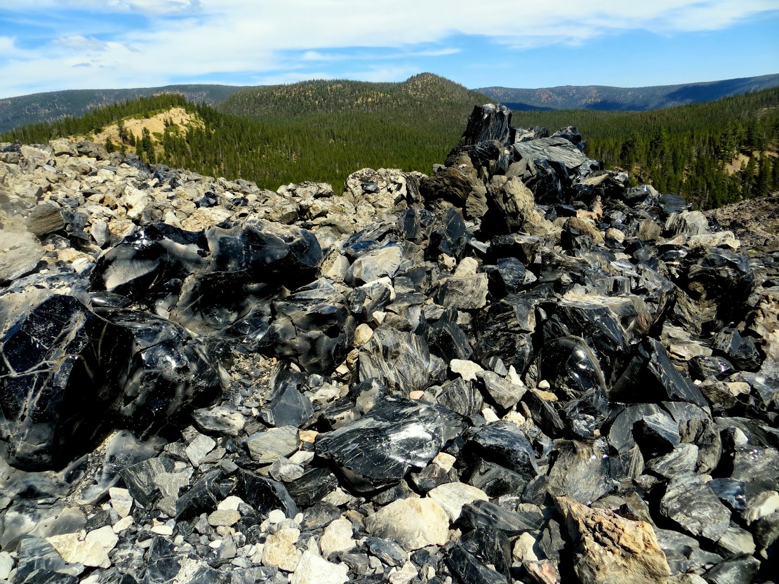
The trail crossed back and forth over the rocky, uneven surface of the Big Obsidian Flow.  We reached the top and were rewarded with this view of Paulina Lake.


Next, we drove to the top of Paulina Peak.  There is a 3 1/2 mile road taking you to the summit of Paulina Peak, 7,984 feet.  From the top, you can view into the Newberry Caldera.  


That's Paulina Lake below.


We visited Benham Falls which has a beautiful 1 mile walking trail leading up to the cascading falls.


There was also 


There is a one mile self guided trail that winds across a 7,000 year old Newberry Volcano basalt lava flow.

As the lava flowed, it enveloped a mature forest taking the shape of the trees as it cooled.  This is just one of the many casts seen throughout the trail.


We also ventured in to the city of Bend a couple of times.  One day we drove to the top of Pilot Butte with amazing views of the city below.  There is also a hiking trail you can take from the bottom up to the top.


We have really enjoyed our time in Bend.  It was a relaxing time with a good mix of activities and downtime.


Friday, September 13, 2013

Crater Lake National Park


Today we decided to make the trip to see Crater Lake National Park.  We knew it would be pretty, but it is impossible to describe the beauty of this lake.  The deep blue waters with the surrounding sheer cliffs is absolutely gorgeous.


We took a two hour trolley tour that drove around the park's 33 mile rim drive.  On board was a park ranger who gave a wonderful narration throughout the tour even at our stopping points.


The lake rests inside a caldera formed approximately 7,700 years ago when a 12,000-foot-tall volcano (Mount Mazama) collapsed following a major eruption. The eruption may have been the largest in North America in the past 640,000 years.

 Melting snow from the mountains flowed down filling the caldera. The depth of the lake is 1,943 feet. The blueness of the water is a result of the other colors in the spectrum are absorbed. Blue wavelengths are scattered and seen by the human eye.

William Gladstone Steel first visited the lake in 1885 and then spent the next 17 years campaigning to protect Crater Lake and making it a national park.  He was successful with the park's creation in 1902.


The island in the middle is Wizard Island and it is actually a cinder cone from a later eruption.


It just seemed like no matter where we looked, it was pure beauty.


The trolley driver snapped this picture of us for our we were there moment.


This is Pumice Castle Overlook, a layer of orange pumice rock that has been eroded into the shape of a medieval castle.


Here is Phantom Ship. This is Crater Lake's "other island". 


It looks tiny in the middle, but it is actually as tall as a 16 story building.


The last stop on our tour was Vidae Falls. A spring fed creek falls over a glacier carved cliff and drops 100 feet.  Since it is so late in the year, the flow is pretty weak.


After our tour we stopped by the Crater Lake Lodge which was built by William Gladstone Steel in 1915.


It was a perfect day to see such a wonderful place!

Thursday, September 12, 2013

A Trip To Lava Butte

We're moving southward bit by bit making the 130 miles drive to the Bend Sunriver Thousand Trails about 20 miles south of Bend, OR.

We really like this park.  It feels more like a state park with enormous sites and each rv site in this section is lined with trees on both sides.  We had no problem getting satellite reception since there is a vacant field next to us on the other side of the trees where Jim was able to just set our dome out there.  We even have cell service (ATT) and Verizon wifi.


We decided we would just take it easy today.  Jim played pickle ball with the 9:00 o'clock group.

Later this afternoon we went over to the Newberry National Volcanic Monument which is only about 10 miles from here.

We planned to take the drive up to Lava Butte.  We stopped at the Visitor's Center to pick up a pass to go up to the top.  It wasn't very crowded as we were able to walk in, pick up the pass and head up to the top.

We took the narrow road with 8% grade that winded around the volcano.


Lava Butte is a cinder cone volcano created during a two phase eruption just over 7,000 years ago.


This is why you need a pass to drive up to the top, there are only 10 parking places.  You have 30 minutes to spend at the top.


We made the climb to the top of the volcano edge.


Here's a view of the inside of the caldera.


Looking down further, you can see the lava flow from the volcano.

We also got a bird's eye view of the Trail of the Molten Lands which winds through the hardened volcanic flow below.
.

There is a 1/4 mile trail that goes around the volcano.  We walked it and on the other side you could see how one side is higher than the other.  You can see the fire lookout tower on the top right.


There were some pretty good views from up there too.


When we made it back to the parking lot, it was time to drive back down.  We went back to the Visitor's Center to look at the exhibits.  I have always been fascinated by volcanoes.

We went out back to walk part of the Trail of the Molten Lands.  Here's a view of Lava Butte from its lava flow.


We have lots more of this park to explore and will be back soon.

See ya' later, little guy.


Tuesday, September 10, 2013

A Trail of Waterfalls

On Monday we drove 17 miles to Silver Falls State Park.  We were looking forward to hiking the Trail of Ten Falls.  It's a popular hike in Oregon where you can make an 8.2 mile loop to view ten waterfalls.  We opted to take the shorter 6.1 mile loop to see seven waterfalls.

It was a beautiful, sunny day with a forecasted high of 82.  We had no trouble finding a parking place, the beauty of going places on a weekday after Labor Day.  :)


The trail begins with a brick walkway taking you by the South Falls Lodge Cafe and Nature Store.


It was a short distance from there we reached the first waterfall, South Falls which is 177 feet high.  We had several viewpoints of the falls before taking the trail under it.  You can see the wooden fence in the middle of the picture showing the trail leading under the falls.


It was pretty neat to walk under the falls and continue on the trail to the next one.  This was one of three waterfalls that you walk under while taking the trail.


We continued on the trail completely shaded by the trails and following South Fork Silver Creek.


The next falls was 8/10 mile.  The Lower South Falls is 93 feet.  It's always amazing how each falls is different.


We now had to follow the trail 1 3/10 miles to the next falls.  The tree on the left had fallen down from the ridge above the trail. It was massive.


The next falls was the Lower North Falls.  It is 30 feet.


We had to divert from the trail 1/10 of a mile to see the next falls, Double Falls, 178 feet.  It you look at the very top over to the left of the tall falls, you can see the other falls coming down.

We thought this would be a good time to eat our sandwich we brought with us.  We were the only ones here for awhile.


Continuing on, we came to Drake Falls, 27 feet.  We weren't able to get a clear picture of the falls.

The next falls was probably our favorite, Middle North Falls, 106 feet.  You walked down to the falls walking underneath.  There's a person down there to the right of the falls to give some perspective.


After walking behind the falls, the trail goes around so you can see the falls from another viewpoint.  To get back on the trail, we needed to go back under the falls.


After viewing the Middle North Falls, we took the turnoff for the Winter Trail and saw our last waterfall for the day, Winter Falls, 134 feet.

This was one of the best hikes we have done.  The trail was wonderfully laid out.  It's not too strenuous and there are lots of places to stop and rest.  I'm sure in the springtime the waterfalls are much stronger, but today was pretty spectacular.