Tales From The Camping House

Tales From The Camping House

Monday, June 27, 2016

Fairbanks, Alaska Part 1

Leaving Delta Junction, we made the short 95 miles drive to Fairbanks.  Actually, we stayed at the Riverview RV Park in North Pole, Alaska.

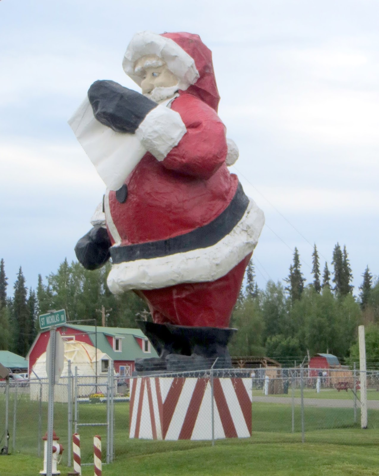
Just down the road is the Santa Claus House open year round.


The whole town has street names such as Santa Claus Lane and the light poles are also wrapped in red to look like candy canes.


Fairbanks is the second largest population center in Alaska with almost 100,000 people living in the area.

We kept busy with different activities while we were there.

We visited Creamer's Field Migratory Waterfowl Refuge.  From 1928 to 1966, Charles and Anna Creamer ran this successful dairy farm in northern Alaska. As the dairy grew, migratory waterfowl congregated in the fields in larger numbers.  The grain and large open fields provided prime habitat.  When the dairy went up for sale in 1966, the community worked with the state and federal governments to purchase the land as a permanent wildlife refuge.


In early spring  sandhill cranes stopover on their way to their breeding grounds.  The juvenile males stay at Creamer's Field during the summer and then join back with the flock on their return trip south in August.

We watched some of the remaining cranes in the fields of flowers.


We also took a cruise on the Riverboat Discovery.


Once boarded, the riverboat begins it journey down the Chena River.  As we go down the river, there are several stops and demonstrations.

First, a float plane makes a takeoff and landing right beside us as we watch from the boat.


Then we cruised down to where Susan Butcher, the four time winner of the Iditarod, lived with her family.  Sadly, she passed away in 2010, but today we are greeted by her husband, David Monson,
to tell us about and demonstrate dogsledding.


In the winter, the Chena River freezes over and dogsled teams are taken down the river.


Continuing down the river, we came to the spot where the Chena and Nanana Rivers merge.  You can see the difference in the two rivers, one being full of glacial silt and the other a deeper gray color.


We turned around on the Chena River and continued back to a replica of an Atabascan fishing camp.  We got off the ship to tour several spot in the village,

which also included a stop to watch a herd of reindeer.


We learned about how salmon was fished and dried by these early inhabitants.

We really enjoyed this afternoon cruise.  Stay tuned to Part 2 of our time in Fairbanks.

Thursday, June 23, 2016

Delta Junction


We left Tok after our overnight stay on our way to our next destination in Delta Junction.  There were several scenic overlooks we stopped at.


And of course, road construction.  This one had a water truck going in front of us to keep dust down.


We stopped at Delta Meat and Sausage for some samples.  We really liked their sausage and left with more than we came with. :)

We arrived at the Visitor's Center in Delta Junction and had our obligatory picture taken at the Mile Marker noting the End of the Alaska Highway.


Jim also had his picture taken with the big mosquito.

We left Delta Junction and proceeded ten miles down the road to Rika's Roadhouse.  This was a popular stop during the early Alcan Highway days, but is now a historic park.  You can also stay overnight here in their parking lot for $5 which we did.

There are a lot of historic and informational displays and building here.

This was the main house with the guest rooms.


Inside are more informative displays.


We left the park and went around to the highway to get our first glimpse of the Alaskan pipeline.


It's something we have heard about all our lives and it's pretty impressive to see it in person.


Tomorrow, our next stop Fairbanks, Alaska's second largest city.

Wednesday, June 22, 2016

We Weren't Going To Do It

From the beginning, we had said we were not going to do the Top of the World Highway.  I had just read too many mixed reviews and didn't think it was worth the wear and tear of the rig over the gravel roads.  

The road is 79 miles long running from Dawson City to the Alaskan border.  

We started out with minimal traffic.  It was dusty, there were some revs that passed us and some that we passed.

I think there were only 2 big trucks that passed us going the other way and we both slowed down.


We went slowly and enjoyed the views.


You truly are on top of the world.

We were up so high, there was still snow patches by the side of the road.

The road on the Canada side was really not that bad.  We went slow and everything seemed to be ok.


We reached the U.S. border and after a few questions, we were back in the U.S.A.!


This is the most picturesque Welcome to Alaska sign I have taken yet.


Then, we were greeted with the best 19 miles of road we have probably traveled the entire trip.

But then it ended, and we had the worst washboarded road.  We had to slow down to between 10-15 mph on long stretches of the road.


We reached the town of Chicken.

We looked around a bit and proceeded on to Tok which would be our overnight stop.

It took us about 6 hours to go 185 miles, but we are now in mainland Alaska!  I have no desire to take that road again.

Tuesday, June 21, 2016

Whitehorse to Dawson City

We left Whitehorse and turned right on the Klondike Highway on the way to Dawson City.  

There were some great views of the Yukon River from the highway.


At another highway overlook we spotted this moose chomping on the marshy grasses.


We saw this bear on the edge of the highway and stopped to watch until it disappeared into the woods.  It looked like it had recently tangled with something else looking at the wound on the hind leg.


We traveled about 160 miles today to Pelly Crossing and stayed at the campground across the street from the general store.  It was a great campground on the river, no hookups, but free!


I don't know if you ever get really used to the never-ending days.  I love them myself, but we have learned to totally black out our bedroom so we can sleep at night.

This picture was taken at 10:30 p.m.

The next day we left Pelly Crossing to travel the next 150 miles to Dawson City, the final destination for many of the "stampeders" during the Klondike Gold Rush.  Once we arrived in Dawson City, we planned to take the George Black Ferry over the Yukon River and stay at the Yukon River Provincial Campground.   The ferry goes back and forth 24 hours a day during the summer.  They are very experienced in handling the rv traffic and we had no problem getting on (we were first in line) and off at the other side.


Just as soon as we got off the ferry, the Yukon River Campground was on the right.  We drove through some bumpy roads and found this great campsite right on the river.  The Yukon River here is dark and muddy looking, not the pretty blue green we saw in Whitehorse.  It was still nice.


After getting set up, we took the car back over on the ferry to check out Dawson City.  This area was also a favorite fishing grounds for members of the First Nations, but when gold was discovered, it became a boomtown.  Most of it probably looks very similar to the way it looked in the early 1900's.


There are raised wooden sidewalks throughout and the streets are still dirt roads.


This is another historic riverboat, the Keno.


You see a lot of cabins like this.


A tour riverboat going down the Yukon.


We also drove up to the top of Midnight Dome where you can see the Yukon River on one side and the Klondike River on the other.

As we were driving back to our campsite, this bird was standing in the middle of the road. I am pretty sure it is a Willow Ptarmigan, the state bird of Alaska.  Of course, we are seeing it in Canada. :)